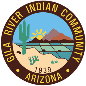
Tribal Seal
The Gila River Indian Community Seal was adopted when the Community was formed in 1939. It was designed by former Council member from District #5 (Casa Blanca), William Pablo, to depict the changing of the environment from that of a dry desert to green life supporting fields through agriculture.
The mountain range represents the various mountain ranges which are located throughout the reservation. These mountain ranges are considered to be very sacred by the Pima. Each mountain was given its own O'otham name by the Huhugam(Ancient Ones).
Today, they are known as the Santan Mountains (JuJulgigk "Zig Zag Connected") , located on the northern reservation boudnary; Sacaton Mountains: Sacaton Peak (Smuk "Pointed"), Agency Peak (Gasso Ki "Fox Butte"), Hayden Peak and the Sierra Estrella Mountains (Komatke) on the west. Others are Gila Butte (Ahgi "Thin"), Pima Butte (Al Ahgi "Little Thin"), Yellow Peak (Hothysaie "Pebbles Thrown At"), and Chev Skomack ("Tall Grey") which is located adjacent to the Santan Mountains.
The Cactus and Greasewood bush symbolizes the vegetation which is common to the desert.
The Sun and the color Blue illustrate that this is being a desert area, the sun is always shining and blue skies are over head most of the year.
The Grid and the color Green is representative of the Pima, and our ancestors the Huhugam, as being an agricultural people. The Huhugam were known for the great canals and irrigation system which they built. To this day, the Pima are farmers of the land, raising such crops as corn, barley, wheat, cotton, watermelon, cantaloupe, and beans.